On the first day of Australia’s GST (July 1, 2000) four intrepid adventurers set forth to follow in the footsteps of David Carnegie, Major Peter Warburton, William Grosse, David Lindsay, Earnest Giles, Alexander Forrest, John Forrest, John McDouall Stuart, Charles Sturt, Harold Lasseter and Len Beadell.
This courageous venture was stimulated partly by the desire to test our survival skills and partly by the desire to momentarily escape the federal government’s $450m advertising campaign and its unconvincing message that the GST will save our nation (what additional tax ever saved any nation?).
The members of the team, under the thoughtful leadership of Commander Gavin Bunning, were carefully chosen for their individual skills. These only became apparent as each day brought new levels of danger and challenge. Peter and Libby Plaskitt, with extensive rural survival skills in many of the worlds trouble spots (including Australia and NZ) had traveled from Sydney to join the expedition. Ron Manners brought Swiss yodeling skills, thought to be necessary for the hazardous mountain ranges lying in our path.
The team members were equipped with special permits to enable one class of Australians to cross ‘another class of Australians land’ and the question was asked: “What outrage would ensue if that other class of Australians had to seek written permits to cross the rest of Australia (ie. the other roads)”?
The following daily notations may assist in identifying the thousands of photos taken as the two week adventure unfolded.
Saturday July 1, 2000
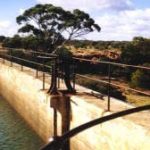
Depart from Perth after finding the two vehicles’ space restrictions made it necessary to leave Ron’s cigar humidor behind. Gavin headed for York. Amy’s Restaurant brings cheer on a rainy night in Kalgoorlie.
Sunday July 2, 2000
 Peter turns back to Perth but is encouraged to continue the expedition. Niagara Dam and warm welcome at Kookynie’s Grand Hotel. Detour to Yundamindra (to authenticate the exterior of our vehicles). (With hindsight we should have visited the excellent Gwalia Museum at Leonora, but a pre-arranged appointment in Laverton prevented this). A Laverton presentation on the proposed Outback Highway, given by its enthusiastic Project Chairman Patrick Hill. Outback Highway developed into Australia’s third major transport route resulting in substantial benefits for all who live along the highway.
The Outback Highway website gives particulars of the route for this proposed all-weather road linking the Stockman’s Hall of Fame at Longreach, Qld, with the Mining Hall of Fame in Kalgoorlie, WA. This highway will enable an east-west, west-east travel loop through Australia’s red centre, returning home across the Nullarbor Highway. We were also provided with a local map that covered the journey from Laverton to the NT border. Out first night under the stars was at campsite ‘P’.
 Monday July 3, 2000
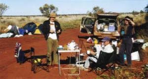
Libby’s discovery that her sleeping companion for the night, had failed the survival test. Result — one squashed field mouse. Inventive juices flow as Gavin’s headlight protectors compete with Peter’s patent tailgate support.
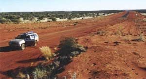
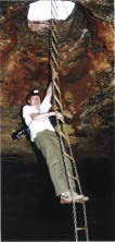 Heading east again, we took our first of seven detours when we decided to visit Empress Spring. An easy 1.5 hour drive north of the Tjukayirla roadhouse along the David Carnegie Road. The spring is in limestone at the end of a tunnel which runs from the base of a seven metre deep cave. A chain ladder allows easy access to the cave. It was named after Queen Victoria, by explorer David Carnegie during his epic 1896 trek from Coolgardie to Halls Creek in the Kimberley Region of WA. An aboriginal man led him to the water which proved to be of immense value to the five members of the party and their camels.
 A most interesting visitors book is stored in a weather-proof metal box at this site. Campsite established at “Fork” (where the old road forks from the new).
Tuesday July 4, 2000
A day of proclamations:
Detour #2: to Giles Meteorological Station and Len Beadle’s Bulldozer display plus the Rocket remnant. Selected a camp (having had a P, then Fork, what should come next?). Onward to Gill Pinnacle Creek Camp.
Ernest Giles — The Explorer
 Ernest Giles was born in Bristol, England in 1835. He came to Australia in 1850. By 1861 he had learned sufficient bushcraft to undertake safaris along the Darling River. He met two men in Melbourne in the 1860’s who were to assist with his later expeditions – William Tietkins (explorer) and Baron von Mueller (Victoria Government Botanist). Giles first explored westwards from the recently completed overland telegraph line (Adelaide to Darwin) in August 1872. He had three men, a dog, and some horses. He failed to reach Mount Olga due to the boggy nature of Lake Amadeus (which he named). His second expedition commenced on August 4, 1873, with Tietkins, Gibson and Andrews. They reached Mount Olga September 14, 1873 and proceeded on to the Warburton Ranges where a lack of water stopped them.
After this they retreated to an area south of the weather station site, and were held up for two months with sickness. On January 16, 1874 they travelled north through the area surrounding the weather station. In April 1874 Gibson was lost whilst exploring an area west of the Rawlinson Range — the Gibson Desert is named for him. The party returned to Mount Olga and Ayers Rock in June 1874. Giles eventually succeeded in crossing the centre of Australia (west to east) in 1876.
He was something of an eccentric, giving colorful names to the features in the area. Under von Mueller’s influence, his botanical collections were first class. He turned to gold prospecting in the 1890’s. He contracted pneumonia, and died on November 20, 1897, aged 62, and is buried in the Coolgardie Cemetery. (Information courtesy of The Giles Weather Station).
Wednesday July 5, 2000
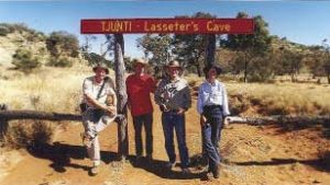 Early morning Gill Pinnacle climb and Docker River, followed by lunch at Lasseter’s Cave.
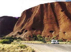
Photographic excursion to the Olga’s for a walking tour and sunset. The joys of a hot shower and bed at Sails in the Desert near Ayers Rock, where an overdue bag of laundry was ‘lodged for processing’.
Thursday July 6, 2000
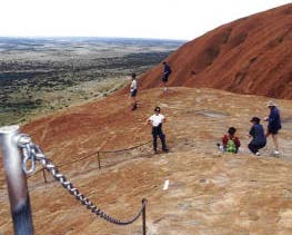
Geko’s breakfast, visitors centre, climbing Ayers Rock (each to their own chosen level). *Mental note: Next time, wear rubber soled joggers. My plastic soled joggers tended to “skate” (I recalled similar problems with these shoes during a midwinter visit to the Great Wall of China). ‘Skated’ down Ayers Rock to photograph the ‘Wall of Shame’ brass plaques to commemorate those who have fallen to their death. Stayed the night at Gill Creek.
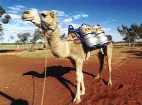 Trained a frisky camel caught at Curtin Springs Homestead — four beer kegs full of water were used to reduce the friskiness.
On the road again via the Lasseter highway with breakfast at Curtin Springs Homestead. Finks-Kulgera Road, via the Finke Aboriginal Community, led us lunch at Goyer Creek. Paused for a photo at the sign to the Lambert Centre (geographic centre of Australia). The Finke River Crossing near New Crown Homestead was exciting. We were assisted by a friendly bulldozer driver).
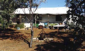
Heading South at Erldunda, instead of North to Alice Springs was a departure from the official Outback Highway. This suited me as I had visited Alice Springs and Longreach (with its impressive Stockmans Hall of Fame) a couple of weeks before, from the Brisbane end. The south-east loop that we took also suited our time constraints. Onward to our detour #3 , to Old Andado Homestead where we were greeted by our famous hostess Molly Clark, one of the great battlers of Central Australia. Also visiting Molly was camelier Andrew Harper and Molly’s warm hospitality enjoyed by all. Old Andado was one of the highlights of our trip and was a great detour. It is important that any intending visitors do as we did, phone before arrival.
 Saturday July 8, 2000
Pre-sunrise walk into the sand dunes to witness the sunrise on the Simpson Desert. Watching the colors change as the sun’s rays accentuated the contours of the sand dunes. Trying to step on the plants so as not to disturb the perfection of the sand dunes. Returned to Finke River Crossing, then to Mt Dare/Bloods Creek/Abminga Creek for lunch before establishing camp at Eringa Billabong.
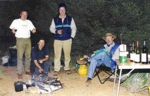
A late night philosophical discussion on how early explorers managed without Engel car-fridges or two-way radios or satellite phones. We were finding them absolutely essential.
Sunday July 9, 2000
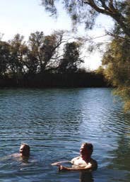 Pre-dawn awakening by birdlife, later combined with Macca’s broadcast birdlife. This caused me to invest a small fortune in a satellite phone call to Macca (Australia All-Over). Noted the bony bream fish winter ‘die off’ around the edge of the Billabong. Off to Dalhousie hot springs for a swim (38-43C) and on to Dalhousie ruins for lunch among the date palms (with a curious dingo eyeing us off).
Monday July 10, 2000
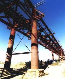
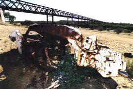
Early departure for Oodnadatta with a visit to the Pink Roadhouse (where I paid $13.95 each for 36 exp. colour films. Compared this to the Perth price of $9.45), Then to the Oodnadatta Rail Station Museum and lunch at Algebuckina Bridge which spans the Neales River. It’s length at 578 metres makes it the longest bridge in SA. We photographed the wrecked car which lay by the southern abutment of the bridge. Many years ago, it had been trying to cross the flooded river by way of the rail bridge and was pushed off by an on-coming train. The driver managed to escape by climbing outside the bridge railing but his dog jumped into the river and was lost.
Our precise schedule was starting to slip and so by two-way radio, we agreed to crank-up the speed a little. “I think we just passed a car parked in the middle of that creek”. A memorable visit to the William Creek Hotel where planes line up in the car park. Supreme Commander Gavin then fearlessly led us across a lakebed to discover an ideal camp site at the almost inaccessible Warburton Mound Spring (alongside Beresford Hill).
Tuesday July 11, 2000
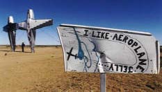
Again we found our swags all iced up and the ice on the Toyota windscreen extended the crack. Washed in the warm water flowing from the Mound Spring outlet, then off at high speed to Marree. Just past the dog-proof fence we came upon Australia’s newest and yet to be publicly reported tourist attraction, “PlaneHenge”. 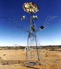
Our first sighting of Lake Eyre South was from the Oodnadatta track. Arrived in Marree just in time for our two hour, (500km) airborne inspection of Lake Eyre at this most opportune time.
Lake Eyre flood history (to July 2000)
Lake Eyre National Park covers an area of 8430 square kilometres. It has filled, or had water in it a number of times in the twentieth century, including 1956, 1971, 1974, 1976, 1989, 1997. The most extensive flooding occurred in 1974 when the lake filled to capacity with up to 34 cubic kilometres of water.
The main river systems which feed Lake Eyre include the inaldn river systems of the Diamantina/Warburton, the Thomson/Barcoo and Cooper, the Georgina/Eyre Creek, the Peake, Neales, Macumba, and Hamilton Rivers. Widespread rains have fallen across the outback during February and April 2000. These rains have brought about a prolific resurgence of activity and breeding of animal and plant life in the SA Outback. While these rains have covered extensive areas of outback Australia and flooded a number of inland rivers, Lake Eyre has increased to back up approximately 75 per cent coverage at present. However, water from the Warburton River flowing into the lake is still flowing.
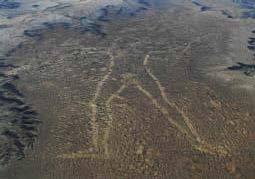
Our flight took us to the north of the lake and demonstrated the abundant birdlife, finishing with a visit to the famous Marree Man, who is celebrating his second birthday.
Detour #4: Later we drove and then walked to the waters edge of Lake Eyre in Madigan Gulf at Level Post Bay, to visit the spot we identified from the air. This ran us into darkness so a suitable campsite was located with a little more difficulty than usual.
Wednesday July 12, 2000
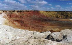
Detour #5: to the Ochre Pits (5km before Lyndhurst). Left our campsite near Muloorina Homestead to return to Marree and then on to Leigh Creek minesite tour. The ochre quarries are of great significance to our Aborigines as they once provided a rich source of multi-coloured ochre used for ceremonial purposes. This particular quarry was an important focus of well defined trade routes extending north into the NT and Queensland and south to the coast. An amnesty arrangement allowed aborigines far removed from this area to visit and take large amounts of ochre. No European mechanical mining has occurred in this quarry.
Lunch at the Quandong Café in Copley before heading off for our next destination, Arkaroola. While at Angepena Homestead we were confronted with two alternative routes to Arkaroola. One was the road everyone seemed to use, the other a dotted line with road-closed signs. Naturally, we took the road less travelled.
This constituted detour #6 and provided an excellent opportunity to practice our driving skills. We still managed to arrive at Arkaroola in time for a magnificent feast of emu cutlets. This was followed by a philosophical discussion on how bad we felt about missing out on the GST introduction fiasco. This pain was partly solved by contemplating the GST’s application to the profession of prostitution. (Would prostitution be classed as a business input or a business output?).
Thursday July 13, 2000
Soaking up the special attractions of Arkaroola:
Finished the day with a memorable meal. During dinner we summarised a day of remarkable activities and had a late night philosophical discussion. Topics included the emerging link between Australia’s growing eco-tourism, “sounds of silence dinners” and “opera in the outback”. This led us to the Outback Highway Project and the Year of the Outback 2002 Project. We ended up talking about the various Halls of Fame, including Mining Hall of Fame (Kalgoorlie). The Stockman’s Hall of Fame (Longreach) and the National Road Transport Hall of Fame (Alice Springs) also got a mention.
What to do about these random bursts of excitement, all these parallel movements? Get them all talking to one another. They provide a richly textured backdrop to the upcoming Year of the Outback 2002 Project.
Friday July 14, 2000
Detailed tactical review undertaken as we moved toward our final destinations. Decision made to take one final detour, #7. Instead of the direct road from Arkaroola to Parachilna, a decision taken to detour via the Flinders Range National Park and Wilpena Pound.
Ron,
Wilpena Pound is just a neat simple basin with very resistant walls of the 600 milliion-year-old pound quartzite sloping up into the air all the way around. So as the country eroded away over the millions of years, the great ramparts were left, above the country around. Many other basins in the moderately folded Flinders Ranges were not quite so clean and symmetrical, or lacked a uniform tough rock type to form such a rim. This simple geological story hides the wonder of how such hard rocks can be folded and warped under pressure and a little heat over geological time, flowing like glaciers do at the surface, or the way bone and wood can be bent under steam. Isn’t Wilpena a wonderful little place. I had to chair a tourism study on the locality when I was in Adelaide, as the govt wanted to promote it. How is it now?
Regards, Ross
The famous tree of Harold Cazneaux (grandfather of Dick Smith). Photographed and named by Cazneaux The Spirit of Endurance with his magnificent words to match.
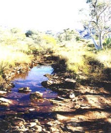
Brachina Geological Gorge was another highlight. A 20km geological trail, a pathway through the rock sequence which reveals its history — a corridor though time.
The result of this Wilpena-Brachina detour was another spectacular day of true treasures of Australiana. Departed Brachina Gorge at sunset after Gavin captured photographic evidence of the yellow footed rock wallabies. Then headed north for the last time to our final night together at The Parachilna Pub (Prairie Hotel).
We arrived within seconds of our pre-booked “feral antipasto, followed by feral mixed grill” dinner appointment. There was a mini-glitch when there was no trace of our accommodation or dinner booking. Some Donga beds were located and the dining experience was worth the debate. The proprietors of this fine establishment were absent in Adelaide receiving a Hospitality Award for their most interesting development. It lines up well with the emerging arsenal of Australiana destinations.
Saturday July 15, 2000
Our Parachilna Pub breakfast was followed by a rapid re-pack of the two vehicles before Caper #1 (Nissan) with Peter and Libby headed south to Adelaide, for their flight to Sydney. Caper #2 (Toyota) headed west with Gavin and Ronaldo who were intent on conquering 2,590km to Perth in time for Sunday nights home cooking with Jenny.
We still made it despite a blown tyre just west of Eucla. Out came the swags until we were in a tyre-changing mood at 5am Sunday. On the road again, but the blowout had lost us our shower time. We still arrived in Perth at 7pm Sunday, looking very much as though we had travelled in the path of Australia’s early explorers, but for several years rather than our brief two weeks.
Total kilometres = 7,190km